Protect Your Project in Philadelphia, PA: The Critical Role of Utility Locating Services
If you build, renovate, or break ground anywhere in Philadelphia, PA, the safest way forward starts with utility locating. In a city with aging infrastructure, tight streets, and dense redevelopment, even a small dig can cross paths with buried gas, water, electric, and telecom lines. That is why partnering with a geophysical team for professional utility locating protects your schedule, budget, and everyone on site.
At American Geophysics Inc., we combine proven methods with near-surface geophysics to verify what lies beneath your work area. The result is clearer decisions, fewer surprises, and a smoother path from preconstruction to closeout.
Why Utility Locating Matters in Philadelphia, PA
Philadelphia blends historic neighborhoods like Old City, Queen Village, and Germantown with active corridors in Center City, University City, and the Navy Yard. Utilities have been upgraded, rerouted, or abandoned over decades. Maps do not always tell the whole story. **Relying on memory or old as-builts can lead to preventable strikes** that cause outages, injuries, and costly delays.
Contacting 811 is a must for public lines, but many private lines on campuses, hospitals, commercial sites, and rowhome properties are not marked through 811. A local provider offering utility locating in Philadelphia, PA helps close that gap so you can dig with confidence.
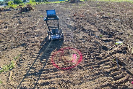
What Professional Utility Locating Includes
Great outcomes start with a clear process. On typical projects, your geophysical team will assess site conditions, choose the right instruments, and document findings so the field and office stay aligned.
- Multi-method scanning to detect metallic and nonmetallic utilities and verify signal continuity
- Surface markings with paint and flags that align to planned work areas and clear pathing
- Depth estimates and utility type identification where conditions allow
- Optional mapping deliverables that support designers and recordkeeping
When concrete surfaces must be cored or cut, pairing locating with concrete imaging reduces risk even more. For a quick primer on that companion step, see our article on what concrete scanning does for you.
Private Lines: The Hidden Risk On Your Site
Private utilities are common across Philadelphia. Think building-to-building electric, site lighting, fire lines, campus fiber, or owner-installed water laterals. These lines often run across alleys in South Philadelphia, through courtyards in Fishtown, or beneath older sidewalks in Fairmount and Northern Liberties.
**Private utilities are not typically marked by 811**, which leaves a blind spot for excavators, drillers, and saw-cutters. A thorough private locate helps reveal those assets so crews avoid damage and rework.
How Geophysical Services Reduce Surprises
Soil type, moisture, and urban noise can affect signal quality. That is why experienced teams combine tools and cross-check results. Ground penetrating radar identifies nonmetallic pipes and unknown features, while electromagnetic locating traces conductive targets. When needed, complementary methods add clarity.
Explore how these tools fit together on our ground penetrating radar page, including when GPR is best for plastics, concrete-encased conduits, or unknown structures.
Philadelphia Realities That Affect Subsurface Work
Local conditions shape how we plan and execute utility locating. Your geophysical partner should understand how city context changes the job.
- Older corridors: Combined sewers, legacy clay tiles, and abandoned service stubs are common in rowhome blocks.
- Tight access: Narrow streets and alleys limit equipment options and demand precise, well-planned markouts.
- Seasonal shifts: Freeze-thaw cycles and saturated soils after spring storms can influence signal response and surface stability.
- Dense utility corridors: In Center City and University City, stacked utilities require careful separation and verification.
Local insight: In South Philadelphia and parts of Kensington, buried private laterals often cross shared alleys at shallow depths. Treat every saw cut, trench, or anchor as a verification moment, and build locating into your plan before permits and scheduling lock in.
When To Schedule Utility Locating For Your Project
Bringing geophysical services in early pays off. It aligns scope, reduces change orders, and helps the entire team work from the same subsurface picture.
- Before soil borings, test pits, or environmental sampling
- Before fence posts, EV chargers, or site lighting upgrades
- Before milling, trenching, or new utility tie-ins
- Before coring, anchoring, or saw-cutting in occupied facilities
Scheduling a locate at design or early precon ensures that utility information informs layout, phasing, and access. **Verifying before drilling or coring saves time and protects structures** that are costly to repair after the fact.
What You Gain: Safety, Certainty, And Speed
Clear marks let operators dig faster. Verified depths help you choose the right equipment. Documented findings support close coordination with the GC, subs, and inspectors. And when everyone trusts the map, logistics and staging improve too.
That is the value of teaming with American Geophysics Inc.. We bring a geophysical lens to construction problems so you can keep people safe, stay on schedule, and protect critical infrastructure.
How We Locate: Methods That Work In The City
Urban environments demand flexible methods and cross-checking. Our approach is designed around the realities of Philadelphia streets and campuses.
Electromagnetic locating traces energized and conductive lines across paved and landscaped areas. It excels at following copper and steel, and it helps confirm line continuity to vaults, boxes, and meters where accessible. GPR fills in the rest by imaging changes in subsurface materials to reveal nonmetallic utilities and unknown features.
On projects with complex routes or future maintenance needs, mapping creates a permanent record that facilities teams can reuse. That record reduces repeat mobilizations and shortens future planning cycles.
From Paint To Plan: Why Documentation Matters
Paint and flags are the fastest way to communicate in the field, but they fade and get covered. A good deliverable pairs those markings with notes, depths where feasible, and alignment to site plans. Designers and superintendents can reference that package to validate conflicts, adjust routing, and prioritize safe excavations.
If your site includes coring or cutting, pairing the locate with concrete imaging keeps slab work on track. For a deeper dive on why contractors rely on imaging, see our quick read on the top benefits of GPR.
Common Use Cases Around Philadelphia
Across Center City towers, Manayunk rehabs, and industrial upgrades along the Delaware River, the goals are the same: verify, protect, and proceed with clarity.
Examples include:
Soil boring clearance outside a hospital addition in University City, private electric and data laterals between buildings in Old City courtyards, and fire line verification ahead of hydrant moves near the Navy Yard. In each case, coordinated utility locating let crews work only where needed, reducing disruption to neighbors and traffic.
Build Utility Locating Into Your Plan
Planning is your best safety tool. Add locating to your precon checklist next to permits, traffic control, and material staging. Share scope and drawings with your geophysical team so we can tailor the approach to your site conditions and timeline.
When you are ready, choose a partner who can scale from a single trench to a campus-wide effort, and who understands how Philadelphia’s patchwork of legacy and modern utilities interact beneath your project.
Ready To Move Forward Safely?
Protect your crews, protect your neighbors, and protect your schedule. Start with American Geophysics Inc. and make utility verification a standard step on every project. Learn more about our utility locating services, then call us at 833-722-6477 to schedule your site review.