
What You Need to Know Before Digging in New Jersey: The Importance of Underground Utility Locating
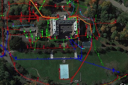
Before any shovel hits the ground in New Jersey, underground utility locating should be part of your plan. Hiring a geophysical partner for utility locating services helps prevent service outages, injuries, and project delays. It is a simple step that gives everyone on site a clearer picture of what lies beneath your work area.
If you build, renovate, or add features like fencing, lighting, or EV chargers, the subsurface can be crowded. Public and private lines often crisscross yards, streets, and sidewalks throughout Newark, Jersey City, Hoboken, Morristown, and the Shore. A reliable locate turns guesswork into confidence so your team can work faster and safer.
Why Underground Utility Locating Matters In New Jersey
New Jersey mixes older neighborhoods with constant redevelopment. Many properties have legacy lines or abandoned stubs that never made it onto current drawings. Relying on memory or aging as-builts can lead to avoidable strikes that stop a job and create expensive repairs.
Contacting 811 helps mark public utilities, but it often does not include private lines that run between buildings, around campuses, or across commercial sites. That is where a qualified geophysical team steps in to find and mark what maps miss. When you need a deeper look, pairing a private mark out with ground penetrating radar builds a more complete picture for planners and field crews.
What Counts As a “Utility” Below Your Site
Utilities are more than just gas and electric. In a tight corridor or older block, several systems may share the same path. Typical targets include:
- Electric, telecom, and fiber lines
- Water, sewer, and storm laterals
- Natural gas services and valves
- Site lighting, irrigation, and fire lines
- Unknown or abandoned lines that no one remembers installing
Good locating does two things. First, it helps crews avoid damaging live lines. Second, it reveals unknowns so your design and staging can adapt early, not in the middle of a pour or trench.
How Geophysical Services Find What Maps Miss
As a geophysical services provider, American Geophysics Inc. blends proven methods to reduce blind spots. Radio frequency tools trace conductive targets where access exists. GPR adds detail by imaging changes in subsurface materials, which helps identify nonmetallic utilities and unknown features. Cross-checking results is key because soil type, moisture, and nearby interference can affect any single method.
When a site calls for documentation beyond paint and flags, deliverables can include plan-aligned sketches, depth estimates where feasible, and notes that help your team revisit the area later without starting from zero. For a quick primer on why GPR is so useful across New Jersey job sites, see our short read on the top benefits of ground penetrating radar.
New Jersey Conditions That Complicate Locates
Local conditions shape the approach. North Jersey often brings dense urban corridors and older clay soils. Shore towns can have sandy backfill and high water tables that change after storms. In fall and winter, freeze–thaw cycles and road salt can influence surface stability and signal clarity.
These realities do not stop a successful locate. They simply mean you benefit from a team that understands how to adjust acquisition paths, verify signal continuity, and document findings in a way your field staff can trust the next day.
When To Schedule Utility Line Locating On Your Project
Bring locating in early so underground realities guide layout and sequencing. A short visit ahead of time helps prevent last-minute changes and keeps inspectors, subs, and owners aligned. Consider booking a locate:
- Before soil borings, test pits, or environmental sampling
- Before trenching, saw cutting, or coring in occupied facilities
- Before setting poles, signs, or fence posts near sidewalks and driveways
- Before connecting to existing water, sewer, or telecom
Adding locating to your preconstruction checklist is like turning the lights on in a dark room. Seeing the layout first saves time and protects people who work inches away from buried hazards.
From Paint To Plan: Underground Utility Mapping And Documentation
Paint and flags communicate quickly, but job sites evolve. When you need a record for future work or closeout, ask about mapping options. Basic sketches tied to landmarks can be enough on small sites. For larger projects, your team may prefer georeferenced mapping that can be shared with designers and facility managers.
Mapping also reduces repeat mobilizations. If you plan multiple phases in places like Princeton, Montclair, or Cherry Hill, a reusable record means crews return with confidence instead of starting fresh each time. When concrete cutting or coring is involved, pairing locating with scanning is smart. For context, you can skim our article on what concrete scanning does for you and how it keeps slab work on track.
Safety First: What Your Crew Gains On Day One
The greatest benefit is safety. Clear marks help operators avoid energized lines and pressurized systems. Verified depths inform the right tooling and keep excavations tidy. Documented findings reduce confusion, especially where multiple trades share a tight work zone.
There is also a scheduling win. With a clear subsurface picture, your superintendent can phase work to avoid conflicts. The difference shows up in fewer change orders and smoother inspections. That is why many general contractors now treat underground utility locating as a standard preconstruction step rather than a nice-to-have.
Choosing A Local Team You Can Trust
Experience matters when the subsurface gets complicated. Look for a partner that can scale from a single trench to a campus-wide effort, and who communicates findings in a way your whole team can use. As a New Jersey based geophysical services provider, American Geophysics Inc. focuses on clarity, safety, and coordination.
If you want a quick overview of our approach or a second opinion on a tricky corridor, reach out. You can learn more about tools and methods on our ground penetrating radar page, then explore other service categories as your project evolves.
Ready To Break Ground With Confidence?
Make underground utility locating part of every plan so you can build with fewer surprises. Talk with American Geophysics Inc. about your schedule, drawings, and site conditions, and we will tailor a right-sized scope for your project. To get started, call 833-722-6477 or learn more about our process on the page for utility locating services.